
Thank you for supporting this site ❤️
Make a donation
Make a donation
Llanfachreth topographic map
Click on the map to display elevation.
Thank you for supporting this site ❤️
Make a donation
Make a donation
About this map
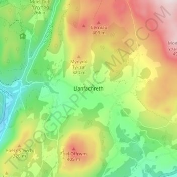
Name: Llanfachreth topographic map, elevation, terrain.
Location: Llanfachreth, Gwynedd, Wales, LL40 2ED, United Kingdom (52.76563 -3.86898 52.80563 -3.82898)
Average elevation: 230 m
Minimum elevation: 9 m
Maximum elevation: 524 m
Thank you for supporting this site ❤️
Make a donation
Make a donation
Other topographic maps
Click on a map to view its topography, its elevation and its terrain.