
Thank you for supporting this site ❤️
Make a donation
Make a donation
Hope topographic map
Click on the map to display elevation.
Thank you for supporting this site ❤️
Make a donation
Make a donation
About this map
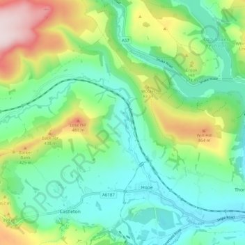
Name: Hope topographic map, elevation, terrain.
Location: Hope, High Peak, Derbyshire, England, United Kingdom (53.33496 -1.80704 53.39368 -1.72547)
Average elevation: 278 m
Minimum elevation: 151 m
Maximum elevation: 579 m
Thank you for supporting this site ❤️
Make a donation
Make a donation
Other topographic maps
Click on a map to view its topography, its elevation and its terrain.
Birch Vale
United Kingdom > England > Derbyshire > High Peak > New Mills > Hayfield
Average elevation: 251 m
Thank you for supporting this site ❤️
Make a donation
Make a donation