
Big Bear Lake topographic map
Interactive map
Click on the map to display elevation.
Big Bear Lake
Since 1970, Big Bear Lake has held an annual Oktoberfest. The Big Bear Lake Oktoberfest sports the highest beer garden, by elevation, in the United States. Big Bear Lake was incorporated as a city on November 28, 1980.
About this map
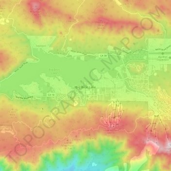
Name: Big Bear Lake topographic map, elevation, terrain.
Average elevation: 2,189 m
Minimum elevation: 1,704 m
Maximum elevation: 2,678 m
Other topographic maps
Click on a map to view its topography, its elevation and its terrain.
Arrowhead
United States > California > San Bernardino County > San Bernardino > Arrowhead
Average elevation: 383 m