
Hampton Butte topographic map
Interactive map
Click on the map to display elevation.
About this map
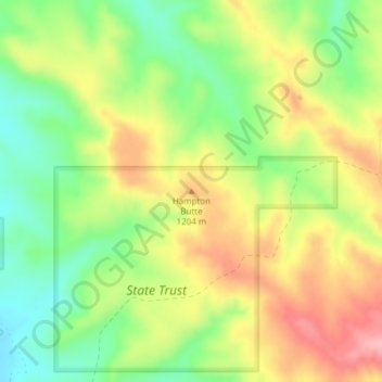
Name: Hampton Butte topographic map, elevation, terrain.
Location: Hampton Butte, Big Horn County, Montana, United States (45.01605 -106.40565 45.01615 -106.40555)
Average elevation: 1,169 m
Minimum elevation: 1,109 m
Maximum elevation: 1,235 m
Other topographic maps
Click on a map to view its topography, its elevation and its terrain.
Fort Smith
United States > Montana > Big Horn County
Fort Smith, Big Horn County, Montana, 59035, United States
Average elevation: 1,059 m
Lodge Grass
United States > Montana > Big Horn County > Lodge Grass
Lodge Grass, Big Horn County, Montana, 59050, United States
Average elevation: 1,077 m
Busby
United States > Montana > Big Horn County > Busby
Busby, Busby District, Big Horn County, Montana, 59016, United States
Average elevation: 1,090 m
Black Canyon
United States > Montana > Big Horn County
Black Canyon, Big Horn County, Montana, United States
Average elevation: 1,357 m