
Waiblingen topographic map
Interactive map
Click on the map to display elevation.
About this map
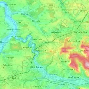
Name: Waiblingen topographic map, elevation, terrain.
Location: Waiblingen, Rems-Murr-Kreis, Bade-Wurtemberg, Allemagne (48.81051 9.27590 48.90912 9.44308)
Average elevation: 285 m
Minimum elevation: 201 m
Maximum elevation: 498 m
Other topographic maps
Click on a map to view its topography, its elevation and its terrain.
Kleinhegnach
Allemagne > Bade-Wurtemberg > Rems-Murr-Kreis > Neustadt
Kleinhegnach, Neustadt, Waiblingen, Rems-Murr-Kreis, Bade-Wurtemberg, 71336, Allemagne
Average elevation: 277 m
Schwaikheim
Allemagne > Bade-Wurtemberg > Rems-Murr-Kreis
Schwaikheim, Gemeindeverwaltungsverband Winnenden, Rems-Murr-Kreis, Bade-Wurtemberg, 71409, Allemagne
Average elevation: 295 m