
Haldensteiner Calanda topographic map
Interactive map
Click on the map to display elevation.
About this map
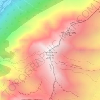
Name: Haldensteiner Calanda topographic map, elevation, terrain.
Average elevation: 2,113 m
Minimum elevation: 928 m
Maximum elevation: 2,792 m
Other topographic maps
Click on a map to view its topography, its elevation and its terrain.
Felsberger Calanda
Schweiz > Sankt Gallen > Pfäfers
Felsberger Calanda, Pfäfers, Wahlkreis Sarganserland, Sankt Gallen, 7012, Schweiz
Average elevation: 2,154 m