
Teufen (AR) topographic map
Interactive map
Click on the map to display elevation.
About this map
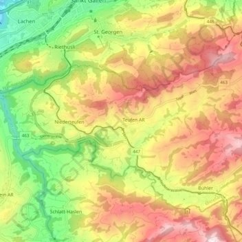
Name: Teufen (AR) topographic map, elevation, terrain.
Location: Teufen (AR), Mittelland, Appenzell Ausserrhoden, Schweiz (47.37706 9.33968 47.40771 9.43600)
Average elevation: 855 m
Minimum elevation: 594 m
Maximum elevation: 1,114 m
Teufen ist eine politische Gemeinde im Mittelland des Kantons Appenzell Ausserrhoden in der Schweiz. Teufen liegt durch eine Anhöhe getrennt unmittelbar südlich der Stadt St. Gallen.
Other topographic maps
Click on a map to view its topography, its elevation and its terrain.
Speicher
Schweiz > Appenzell Ausserrhoden > Mittelland
Speicher, Mittelland, Appenzell Ausserrhoden, Schweiz
Average elevation: 877 m