
Make a donation
Georgetown topographic map
Click on the map to display elevation.
Make a donation
About this map
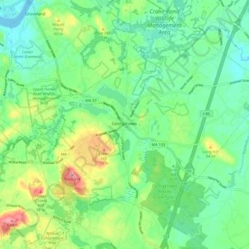
Name: Georgetown topographic map, elevation, terrain.
Location: Georgetown, Essex County, Massachusetts, United States (42.69442 -71.03464 42.75383 -70.92412)
Average elevation: 33 m
Minimum elevation: -3 m
Maximum elevation: 105 m
Make a donation
Other topographic maps
Click on a map to view its topography, its elevation and its terrain.
Make a donation
Whaleback
United States > Massachusetts > Essex County > Manchester-by-the-Sea
Average elevation: 12 m
Make a donation
Deer Island
United States > Massachusetts > Essex County > Amesbury > Salisbury Point
Average elevation: 15 m
Make a donation
Haverhill
United States > Massachusetts > Essex County > Haverhill
According to the United States Census Bureau, the city has a total area of 35.6 square miles (92.3 km2), of which 33.0 square miles (85.4 km2) is land and 2.7 square miles (6.9 km2), or 7.47%, is water. The city ranks 60th in the Commonwealth in terms of land area, and is the largest city or town in Essex…
Average elevation: 45 m
Make a donation
East Point/Henry Cabot Lodge,Jr., Memorial Park
United States > Massachusetts > Essex County > Nahant
Average elevation: 1 m
Make a donation
Make a donation
Make a donation
Make a donation
Amesbury
United States > Massachusetts > Essex County > Amesbury
Amesbury is located at 42°51′29″N 70°55′50″W / 42.85806°N 70.93056°W / 42.85806; -70.93056. According to the United States Census Bureau, the city has a total area of 13.7 square miles (35.5 km2), of which 12.3 square miles (31.8 km2) is land and 1.5 square miles (3.8 km2), or 10.65%, is…
Average elevation: 24 m
Make a donation
South Salem
United States > Massachusetts > Essex County > Salem > South Salem
Average elevation: 11 m
Make a donation
Veasey Memorial Park
United States > Massachusetts > Essex County > Groveland > South Groveland
Average elevation: 34 m
Dix Park
United States > Massachusetts > Essex County > Beverly > Beverly Farms
Average elevation: 19 m
Make a donation