
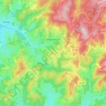
Villapourçon topographic map
Interactive map
Click on the map to display elevation.
About this map
Name: Villapourçon topographic map, elevation, terrain.
Average elevation: 509 m
Minimum elevation: 292 m
Maximum elevation: 856 m
Other topographic maps
Click on a map to view its topography, its elevation and its terrain.
Solo
Frankreich > Burgund und Freigrafschaft > Nièvre > Saint-Léger-de-Fougeret
Solo, Saint-Léger-de-Fougeret, Château-Chinon (Ville), Nièvre, Burgund und Freigrafschaft, Metropolitanes Frankreich, 58120, Frankreich
Average elevation: 414 m
Lavaux
Frankreich > Burgund und Freigrafschaft > Nièvre > Moux-en-Morvan
Lavaux, Moux-en-Morvan, Château-Chinon (Ville), Nièvre, Burgund und Freigrafschaft, Metropolitanes Frankreich, 58230, Frankreich
Average elevation: 585 m
Le Chemin de Saint-Leonard
Frankreich > Burgund und Freigrafschaft > Nièvre > Beaulieu
Le Chemin de Saint-Leonard, Michaugues, Beaulieu, Clamecy, Nièvre, Burgund und Freigrafschaft, Metropolitanes Frankreich, 58420, Frankreich
Average elevation: 240 m
Bise
Frankreich > Burgund und Freigrafschaft > Nièvre > Moux-en-Morvan > Bise
Bise, Moux-en-Morvan, Château-Chinon (Ville), Nièvre, Burgund und Freigrafschaft, Metropolitanes Frankreich, 58230, Frankreich
Average elevation: 544 m
Magny-Cours
Frankreich > Burgund und Freigrafschaft > Nièvre > Magny-Cours
Magny-Cours, Nevers, Nièvre, Burgund und Freigrafschaft, Metropolitanes Frankreich, 58470, Frankreich
Average elevation: 214 m