
Thank you for supporting this site ❤️
Make a donation
Make a donation
Lānaʻi topographic map
Click on the map to display elevation.
Thank you for supporting this site ❤️
Make a donation
Make a donation
Lānaʻi
The highest point in Lanai is Mount Lānaʻihale. It is an inactive volcano near the center of the island and to the east of Lanai City. The elevation of Mount Lānaʻihale is 3,366 ft (1,026 m).
Thank you for supporting this site ❤️
Make a donation
Make a donation
About this map
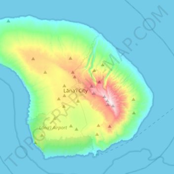
Name: Lānaʻi topographic map, elevation, terrain.
Location: Lānaʻi, Maui County, Hawaii, 96763, United States (20.73171 -157.06163 20.92934 -156.80555)
Average elevation: 162 m
Minimum elevation: 0 m
Maximum elevation: 1,020 m
Thank you for supporting this site ❤️
Make a donation
Make a donation