
Thank you for supporting this site ❤️
Make a donation
Make a donation
Abel topographic map
Click on the map to display elevation.
Thank you for supporting this site ❤️
Make a donation
Make a donation
About this map
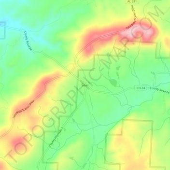
Name: Abel topographic map, elevation, terrain.
Location: Abel, Cleburne County, Alabama, United States (33.52872 -85.73246 33.56872 -85.69246)
Average elevation: 306 m
Minimum elevation: 213 m
Maximum elevation: 430 m
Thank you for supporting this site ❤️
Make a donation
Make a donation
Other topographic maps
Click on a map to view its topography, its elevation and its terrain.