
Huffs Church topographic map
Interactive map
Click on the map to display elevation.
About this map
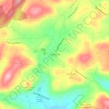
Name: Huffs Church topographic map, elevation, terrain.
Average elevation: 261 m
Minimum elevation: 182 m
Maximum elevation: 336 m
Other topographic maps
Click on a map to view its topography, its elevation and its terrain.
Hereford
United States > Pennsylvania > Berks County > Hereford Township
Hereford, Hereford Township, Berks County, Pennsylvania, 18056, United States
Average elevation: 173 m
Harlem
United States > Pennsylvania > Berks County > Hereford Township
Harlem, Hereford Township, Berks County, Pennsylvania, 18056, United States
Average elevation: 256 m
Seisholtzville
United States > Pennsylvania > Berks County > Hereford Township
Seisholtzville, Hereford Township, Berks County, Pennsylvania, 18011, United States
Average elevation: 260 m
Chapel
United States > Pennsylvania > Berks County > Hereford Township
Chapel, Hereford Township, Berks County, Pennsylvania, 18070, United States
Average elevation: 139 m
Clayton
United States > Pennsylvania > Berks County > Hereford Township
Clayton, Hereford Township, Berks County, Pennsylvania, 19503, United States
Average elevation: 172 m