
Caspian topographic map
Interactive map
Click on the map to display elevation.
About this map
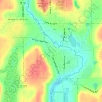
Name: Caspian topographic map, elevation, terrain.
Average elevation: 463 m
Minimum elevation: 435 m
Maximum elevation: 495 m
Other topographic maps
Click on a map to view its topography, its elevation and its terrain.
Ice Lake
Vereinigte Staaten von Amerika > Michigan > Iron County > Iron River
Ice Lake, Iron River, Bates Township, Iron County, Michigan, Vereinigte Staaten von Amerika
Average elevation: 489 m
Bates Township
Vereinigte Staaten von Amerika > Michigan > Iron County
Bates Township, Iron County, Michigan, Vereinigte Staaten von Amerika
Average elevation: 469 m