
Thank you for supporting this site ❤️
Make a donation
Make a donation
Plage Caraïbe topographic map
Click on the map to display elevation.
Thank you for supporting this site ❤️
Make a donation
Make a donation
About this map
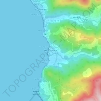
Name: Plage Caraïbe topographic map, elevation, terrain.
Average elevation: 80 m
Minimum elevation: 0 m
Maximum elevation: 434 m
Thank you for supporting this site ❤️
Make a donation
Make a donation
Other topographic maps
Click on a map to view its topography, its elevation and its terrain.
Plage de l'Anse Caraïbe
France > Guadeloupe > Pointe-Noire > Mahault > Plage Caraïbe
Average elevation: 53 m