
Make a donation
County Galway topographic map
Click on the map to display elevation.
Make a donation
About this map
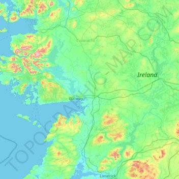
Name: County Galway topographic map, elevation, terrain.
Location: County Galway, Connacht, Ireland (52.96818 -10.31428 53.71886 -7.96782)
Average elevation: 68 m
Minimum elevation: -2 m
Maximum elevation: 772 m
Make a donation
Other topographic maps
Click on a map to view its topography, its elevation and its terrain.
Make a donation
Make a donation
Make a donation
Morning Star
Ireland > County Limerick > The Municipal District of Cappamore — Kilmallock
Average elevation: 46 m
Make a donation
Limerick
Ireland > County Limerick > Limerick
Limerick's climate is classified as temperate oceanic (Köppen Cfb). Met Éireann maintains a climatological weather station at Shannon Airport, 20 kilometres west of the city in County Clare. Shannon Airport records an average of 977 millimetres of precipitation annually, most of which is rain. Limerick has a…
Average elevation: 10 m