
Thank you for supporting this site ❤️
Make a donation
Make a donation
Cabanelles topographic map
Click on the map to display elevation.
Thank you for supporting this site ❤️
Make a donation
Make a donation
About this map
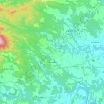
Name: Cabanelles topographic map, elevation, terrain.
Location: Cabanelles, Alt Empordà, Gerona, Catalonië, 17746, Spanje (42.17919 2.71329 42.30609 2.86129)
Average elevation: 206 m
Minimum elevation: 54 m
Maximum elevation: 905 m
Thank you for supporting this site ❤️
Make a donation
Make a donation
Other topographic maps
Click on a map to view its topography, its elevation and its terrain.
El Port de la Selva
Spanje > Catalonië > Alt Empordà > el Port de la Selva > El Port de la Selva
Average elevation: 76 m