
Mungeli topographic map
Click on the map to display elevation.
About this map
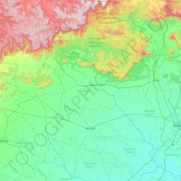
Name: Mungeli topographic map, elevation, terrain.
Location: Mungeli, Chhattisgarh, India (21.81389 81.46982 22.67535 82.03622)
Average elevation: 422 m
Minimum elevation: 227 m
Maximum elevation: 1,072 m
Other topographic maps
Click on a map to view its topography, its elevation and its terrain.
Bhilai
India > Chhattisgarh > Durg Tahsil
Bhilai lies at 21.21°N 81.38°E in Central India at an elevation of 297m above sea level on the banks of the Shivnath river, a tributary of the river Mahanadi. It covers an area of 341 km2 (132 sq mi).
Average elevation: 292 m
Kapsi
India > Chhattisgarh > Pakhanjur Tahsil
Geographically, it lies in the northern lowlands of the Bastar plateau and is a part of the historical Dandakaranya region. The elevation of the village ranges from 310 m (1,020 ft) to 330 m (1,080 ft) above sea level. The Devda ravine, a tributary of Kotri river, meanders through the heart of the village and…
Average elevation: 325 m
Raigarh
India > Chhattisgarh > Raigarh Tahsil
Raigarh is located at 21°54′N 83°24′E / 21.9°N 83.4°E / 21.9; 83.4. It has an average elevation of 215 metres (705 feet). The Kelo river flows through the city, which is one of its main water sources.
Average elevation: 216 m
Kirandul
India > Chhattisgarh > Kuakonda Tahsil
The Kothavalasa–Kirandul line of East Coast Railway from Kirandul to Visakhapatnam via Koraput is laid through the Eastern Ghats. Up to Araku station, it has many tunnels. Also it pass through the highest elevation Broad gauge station in the Eastern ghats, Semiliguda, just before the Borra caves. Kirandul -…
Average elevation: 742 m
Gariaband
India > Chhattisgarh > Bindranavagarh(Gariyaband) Tahsil
Gariaband is Loceted on 20°38′N 82°03′E / 20.63°N 82.05°E / 20.63; 82.05. Gariaband has an average elevation of 318 metres (1043 ft).
Average elevation: 346 m
Champa
India > Chhattisgarh > Champa Tahsil
Champa has an average elevation of 253 metres (830 feet). It is located on the banks of Hasdeo river, a tributary of Mahanadi.
Average elevation: 254 m
Kanker
India > Chhattisgarh > Kanker Tahsil
Kanker is located at 20°16′N 81°29′E / 20.27°N 81.49°E / 20.27; 81.49. It has an average elevation of 388 metres (1272 feet).
Average elevation: 405 m
Sukma
India > Chhattisgarh > Sukma Tahsil
It is located at 18°24′0″N 81°40′0″E / 18.40000°N 81.66667°E / 18.40000; 81.66667 at an elevation of 210 m above MSL.
Average elevation: 219 m
Kharsia
India > Chhattisgarh > Kharsia Tahsil
Kharsia is located at 21°58′N 83°07′E / 21.97°N 83.12°E / 21.97; 83.12. It has an average elevation of 245 m (804 ft).
Average elevation: 253 m
Kawardha
India > Chhattisgarh > Kawardha Tahsil
Kawardha is located at 22°01′N 81°15′E / 22.02°N 81.25°E / 22.02; 81.25. The total area is 798 square miles (2,070 km2). The state consists of hills and forests. It has an average elevation of 353 metres (1,158 ft).
Average elevation: 350 m
Pendra
India > Chhattisgarh > Pendra Tahsil
Pendra has an average elevation of 617 metres (2,024 ft).
Average elevation: 594 m
Bhilai
India > Chhattisgarh > Durg Tahsil
Bhilai lies at 21.21°N 81.38°E in Central India at an elevation of 297m above sea level on the banks of the Shivnath river, a tributary of the river Mahanadi. It covers an area of 341 km2 (132 sq mi).
Average elevation: 292 m
Kharsia
India > Chhattisgarh > Kharsia Tahsil
Kharsia is located at 21°58′N 83°07′E / 21.97°N 83.12°E / 21.97; 83.12. It has an average elevation of 245 m (804 ft).
Average elevation: 253 m
Balod
India > Chhattisgarh > Balod Tahsil
Balod is located at 20°44′N 81°12′E / 20.73°N 81.2°E / 20.73; 81.2. It has an average elevation of 324 metres (1063 feet).
Average elevation: 323 m
Kanker
India > Chhattisgarh > Kanker Tahsil
Kanker is located at 20°16′N 81°29′E / 20.27°N 81.49°E / 20.27; 81.49. It has an average elevation of 388 metres (1272 feet).
Average elevation: 405 m
Balod
India > Chhattisgarh > Balod Tahsil
Balod is located at 20°44′N 81°12′E / 20.73°N 81.2°E / 20.73; 81.2. It has an average elevation of 324 metres (1063 feet).
Average elevation: 323 m