
Make a donation
Buleleng topographic map
Click on the map to display elevation.
Make a donation
Buleleng
Buleleng Regency, located in the north of Bali Island, has a very diverse topography, consisting of lowlands, hills, and mountains. Most of the Buleleng Regency area is a hilly and mountainous area stretching in the south, while in the north, namely along the coast, is a lowland. These unique conditions make the topography of Buleleng Regency often called Nyegara Gunung.
Make a donation
About this map
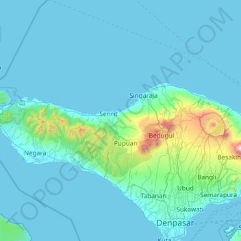
Name: Buleleng topographic map, elevation, terrain.
Location: Buleleng, Bali, Lesser Sunda Islands, Indonesia (-8.38281 114.41513 -7.46280 115.83242)
Average elevation: 99 m
Minimum elevation: 0 m
Maximum elevation: 2,894 m
Make a donation
Other topographic maps
Click on a map to view its topography, its elevation and its terrain.
Make a donation
Make a donation
Make a donation
Make a donation
Make a donation
Make a donation
Make a donation
Make a donation
Make a donation
Make a donation
Make a donation
Make a donation
Make a donation
Make a donation
Make a donation
Mount Agung
Indonesia > Bali > Karangasem
Australia's Bureau of Meteorology reported on 27 November that ash from the eruption had been observed at an altitude of 9,144 m. By the beginning of December, the eruption reduced to minor emissions of steam and smoke. On 12 December, a picture of the crater was taken showing a steadily growing lava dome…
Average elevation: 2,534 m
Make a donation
Make a donation
Make a donation
Make a donation
Make a donation
Point of view on the lake and the mount Batur
Indonesia > Bali > Bangli > Songan B
Average elevation: 1,059 m
Make a donation
Make a donation
Make a donation
Make a donation
Make a donation