
Vichuquén topographic map
Interactive map
Click on the map to display elevation.
About this map
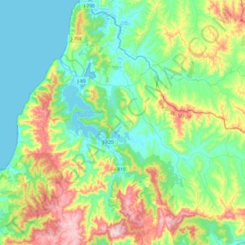
Name: Vichuquén topographic map, elevation, terrain.
Location: Vichuquén, Provincia de Curicó, Maule Region, Chile (-34.97455 -72.15830 -34.68453 -71.86849)
Average elevation: 130 m
Minimum elevation: -1 m
Maximum elevation: 461 m
Other topographic maps
Click on a map to view its topography, its elevation and its terrain.
Guaico Tres
Chile > Maule Region > Provincia de Curicó > Romeral
Guaico Tres, Romeral, Provincia de Curicó, Maule Region, Chile
Average elevation: 449 m
Molina
Chile > Maule Region > Provincia de Curicó
Molina, Provincia de Curicó, Maule Region, Chile
Average elevation: 669 m
Curicó
Chile > Maule Region > Provincia de Curicó
Curicó, Provincia de Curicó, Maule Region, Chile
Average elevation: 658 m