
Gutenswil topographic map
Interactive map
Click on the map to display elevation.
About this map
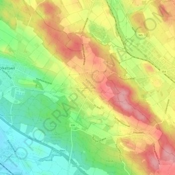
Name: Gutenswil topographic map, elevation, terrain.
Location: Gutenswil, Volketswil, Bezirk Uster, Zürich, 8605, Schweiz (47.36540 8.69805 47.40540 8.73805)
Average elevation: 519 m
Minimum elevation: 448 m
Maximum elevation: 591 m
Other topographic maps
Click on a map to view its topography, its elevation and its terrain.
Kindhausen
Schweiz > Zürich > Bezirk Uster > Volketswil > Kindhausen
Kindhausen, Volketswil, Bezirk Uster, Zürich, 8604, Schweiz
Average elevation: 501 m