
Tuxtla Gutiérrez topographic map
Interactive map
Click on the map to display elevation.
About this map
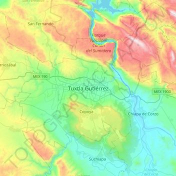
Name: Tuxtla Gutiérrez topographic map, elevation, terrain.
Location: Tuxtla Gutiérrez, Chiapas, 29000, Mexiko (16.59380 -93.27596 16.91380 -92.95596)
Average elevation: 817 m
Minimum elevation: 377 m
Maximum elevation: 1,745 m
Tuxtla Gutiérrez liegt im Becken des Río Grijalva in einer Höhe von etwa 520 m ü. d. M. Die in der Kolonialzeit gegründete Stadt Chiapa de Corzo befindet sich etwa 15 km südöstlich.