
Angleur topographic map
Interactive map
Click on the map to display elevation.
About this map
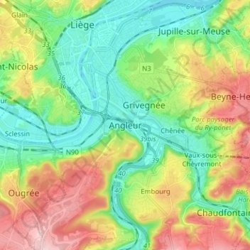
Name: Angleur topographic map, elevation, terrain.
Location: Angleur, Liège, Wallonie, 4000, Belgique (50.57284 5.55531 50.65284 5.63531)
Average elevation: 135 m
Minimum elevation: 54 m
Maximum elevation: 271 m
Other topographic maps
Click on a map to view its topography, its elevation and its terrain.
Jupille-sur-Meuse
Belgique > Liège > Liège > Liège
Jupille-sur-Meuse, Liège, Wallonie, 4000, Belgique
Average elevation: 133 m