
Make a donation
Wonersh topographic map
Click on the map to display elevation.
Make a donation
Wonersh
The parish rises from west to east up the eroded basin of Cranleigh Waters holding the villages to the flint, clay, greensand and sandy soil topped Greensand Ridge. Elevations vary from 39 m (128 ft) AOD by the Bramley/Wonersh bridge over the stream to 207 m (679 ft) at the car park on Winterfold Hill, Winterfold Heath.
Make a donation
About this map
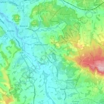
Name: Wonersh topographic map, elevation, terrain.
Location: Wonersh, Waverley, Surrey, England, United Kingdom (51.16166 -0.55558 51.21345 -0.47929)
Average elevation: 79 m
Minimum elevation: 33 m
Maximum elevation: 201 m
Make a donation
Other topographic maps
Click on a map to view its topography, its elevation and its terrain.
Make a donation
Make a donation
Hankley Common
United Kingdom > England > Surrey > Waverley > Thursley > Truxford
Average elevation: 70 m
Make a donation
Make a donation
Camelsdale
United Kingdom > England > Surrey > Waverley > Haslemere > Shottermill
Average elevation: 166 m
Make a donation
Make a donation
Make a donation
Floodplain (seasonal)
United Kingdom > England > Surrey > Waverley > Farnham > Wrecclesham
Average elevation: 94 m
Make a donation