
Fuente Dé topographic map
Interactive map
Click on the map to display elevation.
About this map
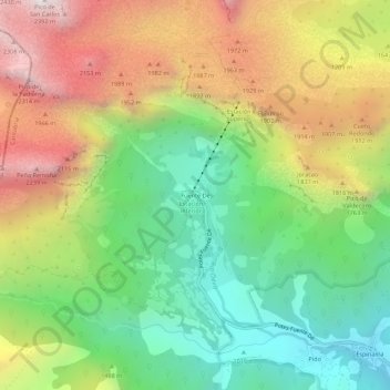
Name: Fuente Dé topographic map, elevation, terrain.
Location: Fuente Dé, Camaleño, Cantabria, 39588, España (43.12403 -4.83148 43.16403 -4.79148)
Average elevation: 1,505 m
Minimum elevation: 853 m
Maximum elevation: 2,378 m
Other topographic maps
Click on a map to view its topography, its elevation and its terrain.
Montes Subiedes
Montes Subiedes, Camaleño, Liébana, Cantabria, 39582, España
Average elevation: 857 m
Pico del Buey
Pico del Buey, Camaleño, Liébana, Cantabria, 39588, España
Average elevation: 1,462 m