
Maui topographic map
Interactive map
Click on the map to display elevation.
About this map
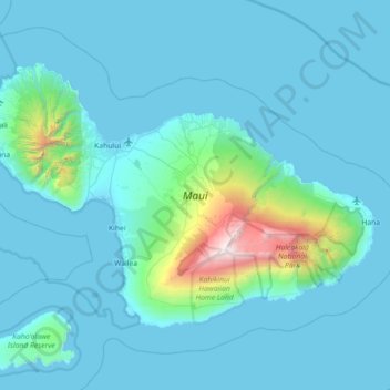
Name: Maui topographic map, elevation, terrain.
Location: Maui, Maui County, Hawaii, United States (20.57443 -156.69726 21.03156 -155.97909)
Average elevation: 232 m
Minimum elevation: -4 m
Maximum elevation: 3,044 m
Maui's diverse landscapes are the result of a unique combination of geology, topography, and climate. Each volcanic cone in the chain of the Hawaiian Islands is built of [basalt], a dark, iron-rich/silica-poor rock, which poured out of thousands of vents as highly fluid lava over millions of years. Several of the volcanoes were close enough to each other that lava flows on their flanks overlapped one another, merging into a single island. Maui is such a "volcanic doublet," formed from two shield volcanoes that overlapped one another to form an isthmus between them.
Other topographic maps
Click on a map to view its topography, its elevation and its terrain.
Kula
United States > Hawaii > Maui County
Kula, Maui County, Hawaii, 96790, United States
Average elevation: 740 m