
Make a donation
Baton Rouge topographic map
Click on the map to display elevation.
Make a donation
Baton Rouge
Baton Rouge is on the banks of the Mississippi River in southeastern Louisiana's Florida Parishes region. The city is about 79 miles (127 km) from New Orleans, 126 miles (203 km) from Alexandria, 56 miles (90 km) from Lafayette and 250 miles (400 km) from Shreveport. It is also 173 miles (278 km) from Jackson, Mississippi and 272 miles (438 km) from Houston, Texas. Baton Rouge lies on a low elevation of 56 to a little over 62 feet above sea level.
Make a donation
About this map
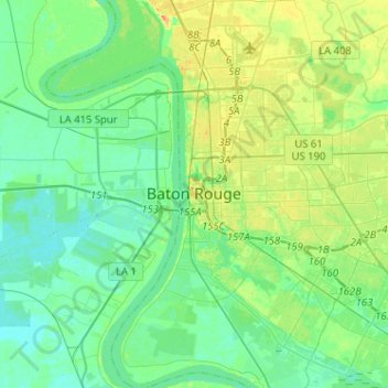
Name: Baton Rouge topographic map, elevation, terrain.
Average elevation: 12 m
Minimum elevation: 1 m
Maximum elevation: 37 m
Make a donation
Other topographic maps
Click on a map to view its topography, its elevation and its terrain.
Nicholson Estates
United States > Louisiana > East Baton Rouge Parish > Baton Rouge
Average elevation: 11 m
Make a donation
Carmen Terrace
United States > Louisiana > East Baton Rouge Parish > Baton Rouge
Average elevation: 16 m
Make a donation
Bell Fontaine
United States > Louisiana > East Baton Rouge Parish > Baton Rouge
Average elevation: 16 m
Marwede Place
United States > Louisiana > East Baton Rouge Parish > Baton Rouge
Average elevation: 17 m
Goodwood Estates
United States > Louisiana > East Baton Rouge Parish > Baton Rouge
Average elevation: 17 m
Sherwood Forest
United States > Louisiana > East Baton Rouge Parish > Baton Rouge
Average elevation: 16 m
Make a donation
Magnolia Heights
United States > Louisiana > East Baton Rouge Parish > Baton Rouge
Average elevation: 11 m
Make a donation
Monte Sano Trailer Park
United States > Louisiana > East Baton Rouge Parish > Baton Rouge > Monte Sano Trailer Park
Average elevation: 21 m
University Terrace
United States > Louisiana > East Baton Rouge Parish > Baton Rouge > University Terrace
Average elevation: 11 m
Sharon Hills
United States > Louisiana > East Baton Rouge Parish > Sharon Hills
Average elevation: 20 m
Make a donation