
Municipio Roma I topographic map
Interactive map
Click on the map to display elevation.
About this map
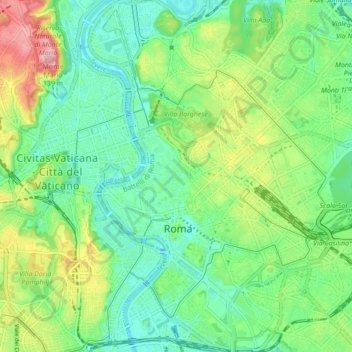
Name: Municipio Roma I topographic map, elevation, terrain.
Location: Municipio Roma I, Rome, RM, Latium, Italie (41.87071 12.43979 41.93514 12.51881)
Average elevation: 51 m
Minimum elevation: 5 m
Maximum elevation: 146 m
Other topographic maps
Click on a map to view its topography, its elevation and its terrain.
Municipio Roma IX
Municipio Roma IX, Rome, RM, Latium, Italie
Average elevation: 81 m