
Thank you for supporting this site ❤️
Make a donation
Make a donation
Davidsonville topographic map
Click on the map to display elevation.
Thank you for supporting this site ❤️
Make a donation
Make a donation
About this map
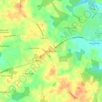
Name: Davidsonville topographic map, elevation, terrain.
Average elevation: 37 m
Minimum elevation: 11 m
Maximum elevation: 60 m
Thank you for supporting this site ❤️
Make a donation
Make a donation
Other topographic maps
Click on a map to view its topography, its elevation and its terrain.
Annapolis
United States > Maryland > Anne Arundel County
Annapolis lies within the humid subtropical climate zone (Köppen Cfa), with hot, humid summers, cool winters, and generous precipitation year-round. Low elevation and proximity to the Chesapeake Bay give the area more moderate spring and summertime temperatures and slightly less extreme winter lows than…
Average elevation: 8 m