
Thank you for supporting this site ❤️
Make a donation
Make a donation
Porter Ranch topographic map
Click on the map to display elevation.
Thank you for supporting this site ❤️
Make a donation
Make a donation
About this map
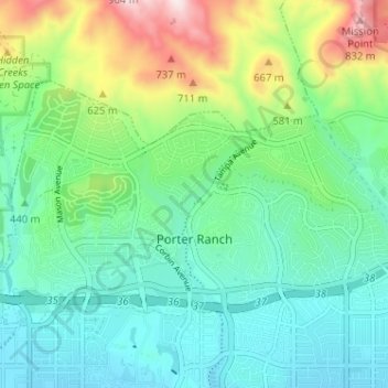
Name: Porter Ranch topographic map, elevation, terrain.
Location: Porter Ranch, Los Angeles, California, United States (34.27233 -118.59165 34.30350 -118.52756)
Average elevation: 460 m
Minimum elevation: 304 m
Maximum elevation: 881 m
Thank you for supporting this site ❤️
Make a donation
Make a donation
Other topographic maps
Click on a map to view its topography, its elevation and its terrain.