
Sumedang topographic map
Interactive map
Click on the map to display elevation.
About this map
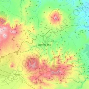
Name: Sumedang topographic map, elevation, terrain.
Location: Sumedang, West-Java, 45321, Indonesien (-7.01924 107.76070 -6.69924 108.08070)
Average elevation: 681 m
Minimum elevation: 51 m
Maximum elevation: 1,845 m
Other topographic maps
Click on a map to view its topography, its elevation and its terrain.
Gunung Tampomas
Indonesien > West-Java > Sumedang
Gunung Tampomas, Sumedang, West-Java, Indonesien
Average elevation: 1,249 m