
Thank you for supporting this site ❤️
Make a donation
Make a donation
Ash Grove topographic map
Click on the map to display elevation.
Thank you for supporting this site ❤️
Make a donation
Make a donation
About this map
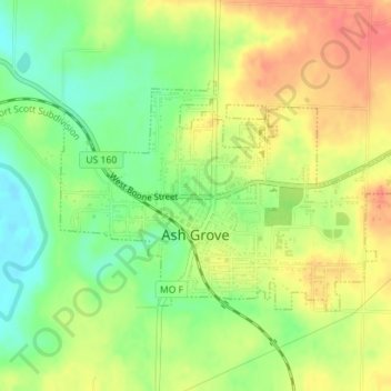
Name: Ash Grove topographic map, elevation, terrain.
Location: Ash Grove, Greene County, Missouri, United States (37.30986 -93.59740 37.32632 -93.56219)
Average elevation: 322 m
Minimum elevation: 291 m
Maximum elevation: 352 m
Thank you for supporting this site ❤️
Make a donation
Make a donation
Other topographic maps
Click on a map to view its topography, its elevation and its terrain.
Thank you for supporting this site ❤️
Make a donation
Make a donation
Thank you for supporting this site ❤️
Make a donation
Make a donation