
Drake topographic map
Interactive map
Click on the map to display elevation.
About this map
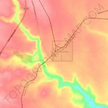
Name: Drake topographic map, elevation, terrain.
Average elevation: 1,417 m
Minimum elevation: 1,328 m
Maximum elevation: 1,446 m
Other topographic maps
Click on a map to view its topography, its elevation and its terrain.
Clarkdale
Vereinigte Staaten von Amerika > Arizona > Yavapai County
Clarkdale, Yavapai County, Arizona, 86324, Vereinigte Staaten von Amerika
Average elevation: 1,211 m
Sedona
Vereinigte Staaten von Amerika > Arizona > Yavapai County
Sedona, Yavapai County, Arizona, 86336, Vereinigte Staaten von Amerika
Average elevation: 1,342 m