
Thank you for supporting this site ❤️
Make a donation
Make a donation
Prairie Village topographic map
Click on the map to display elevation.
Thank you for supporting this site ❤️
Make a donation
Make a donation
About this map
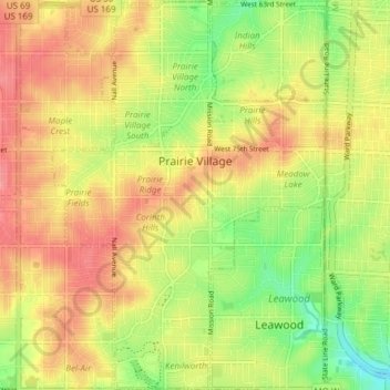
Name: Prairie Village topographic map, elevation, terrain.
Location: Prairie Village, Johnson County, Kansas, United States (38.95677 -94.66109 39.01564 -94.60787)
Average elevation: 300 m
Minimum elevation: 255 m
Maximum elevation: 337 m
Thank you for supporting this site ❤️
Make a donation
Make a donation
Other topographic maps
Click on a map to view its topography, its elevation and its terrain.