
Make a donation
Ritten - Renon topographic map
Click on the map to display elevation.
Make a donation
Ritten - Renon
The 111-square-kilometre (43 sq mi) community is named after the high plateau, elevation 1,100 to 1,400 metres (3,600 to 4,600 ft), the Ritten or the Renon, on which most of the villages are located. The plateau forms the southeast tip of the Sarntal Alps mountain range and is located between, and on average 800 metres (2,600 ft) above the rivers Eisack and Talfer. Ritten lies directly northeast of Bolzano, settled on the "meeting point" of the above rivers.
Make a donation
About this map
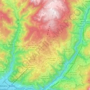
Name: Ritten - Renon topographic map, elevation, terrain.
Average elevation: 1,123 m
Minimum elevation: 257 m
Maximum elevation: 2,257 m
Make a donation
Other topographic maps
Click on a map to view its topography, its elevation and its terrain.
Saslonch - Langkofel - Sassolungo
Italy > Trentino – Alto Adige/Südtirol > South Tyrol > Sëlva - Wolkenstein - Selva di Val Gardena
Average elevation: 2,320 m
Graun im Vinschgau - Curon Venosta
Italy > Trentino – Alto Adige/Südtirol > South Tyrol > Graun - Curon Venosta
Average elevation: 1,794 m