
Castro Laboreiro topographic map
Interactive map
Click on the map to display elevation.
About this map
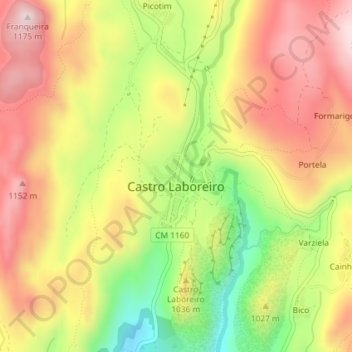
Name: Castro Laboreiro topographic map, elevation, terrain.
Average elevation: 994 m
Minimum elevation: 779 m
Maximum elevation: 1,167 m
Other topographic maps
Click on a map to view its topography, its elevation and its terrain.
Castelo de Castro Laboreiro
Portugal > Nord > Viana do Castelo > Castro Laboreiro e Lamas de Mouro > Castro Laboreiro
Castelo de Castro Laboreiro, CM 1160, Castro Laboreiro, Castro Laboreiro e Lamas de Mouro, Melgaço, Viana do Castelo, Nord, 4960-095, Portugal
Average elevation: 942 m