
Make a donation
Bindersbach topographic map
Click on the map to display elevation.
Make a donation
About this map
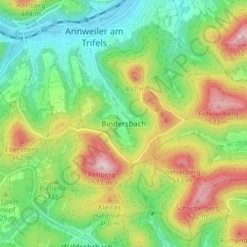
Name: Bindersbach topographic map, elevation, terrain.
Average elevation: 319 m
Minimum elevation: 176 m
Maximum elevation: 549 m
Make a donation
Other topographic maps
Click on a map to view its topography, its elevation and its terrain.
Reichsburg Trifels
Deutschland > Rheinland-Pfalz > Landkreis Südliche Weinstraße > Annweiler am Trifels > Bindersbach
Die Höhenburg Trifels auf der Waldgemarkung von Annweiler steht auf einem dreifach gespaltenen Buntsandsteinfelsen, der 145 m lang, 40 m breit und 50 m hoch ist und die Kuppe des 479 m hohen Sonnenbergs bildet. Von dieser steinernen Basis stammt der Name Trifels, was „dreifacher Fels“ bedeutet. Der…
Average elevation: 297 m
Asselstein
Deutschland > Rheinland-Pfalz > Landkreis Südliche Weinstraße > Annweiler am Trifels > Bindersbach
Average elevation: 309 m