
Upland topographic map
Interactive map
Click on the map to display elevation.
About this map
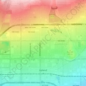
Name: Upland topographic map, elevation, terrain.
Average elevation: 457 m
Minimum elevation: 324 m
Maximum elevation: 650 m
Upland liegt am südlichen Fuß der San Gabriel Mountains. Das Terrain innerhalb des Stadtgebiets ist trotzdem recht flach, steigt jedoch nach Norden leicht an. Von Süden nach Norden nimmt die Höhe von 358 m an der Kreuzung von Euclid Avenue und 7th Street auf einer Länge von sieben Kilometern bis zur 610 m hohen Kreuzung von Euclid Avenue und 24th Street um gut 250 m zu. Der Mount San Antonio, regional auch Mount Baldy genannt, ist der höchste Gipfel der San Gabriel Mountains und liegt ungefähr 15 Kilometer nördlich von Uplands nördlicher Stadtgrenze auf 3068 Metern.
Other topographic maps
Click on a map to view its topography, its elevation and its terrain.
Fontana
Vereinigte Staaten von Amerika > Kalifornien > San Bernardino County
Fontana, San Bernardino County, Kalifornien, Vereinigte Staaten von Amerika
Average elevation: 414 m