
Thank you for supporting this site ❤️
Make a donation
Make a donation
Wurgwitz topographic map
Click on the map to display elevation.
Thank you for supporting this site ❤️
Make a donation
Make a donation
About this map
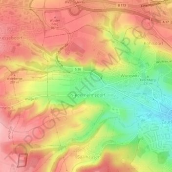
Name: Wurgwitz topographic map, elevation, terrain.
Average elevation: 268 m
Minimum elevation: 185 m
Maximum elevation: 324 m
Thank you for supporting this site ❤️
Make a donation
Make a donation
Other topographic maps
Click on a map to view its topography, its elevation and its terrain.
Windberg
Deutschland > Sachsen > Sächsische Schweiz-Osterzgebirge > Freital
Der Aufstieg von Süden aus Richtung Niederhäslich und von Norden aus Richtung Burgk führt jeweils über steile Wanderwege durch Buchen-, dabei insbesondere Hainbuchen- und Eichenwald hinauf. Von Osten aus Richtung Bannewitz gelangt man ohne die Überwindung größerer Höhenunterschiede zum…
Average elevation: 253 m
Eckersdorf
Deutschland > Sachsen > Sächsische Schweiz-Osterzgebirge > Freital
Average elevation: 288 m