
Thank you for supporting this site ❤️
Make a donation
Make a donation
St Kilda topographic map
Click on the map to display elevation.
Thank you for supporting this site ❤️
Make a donation
Make a donation
About this map
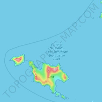
Name: St Kilda topographic map, elevation, terrain.
Location: St Kilda, Western Isles, Scotland, United Kingdom (57.79113 -8.65001 57.88207 -8.48023)
Average elevation: 11 m
Minimum elevation: -2 m
Maximum elevation: 425 m
Thank you for supporting this site ❤️
Make a donation
Make a donation
Other topographic maps
Click on a map to view its topography, its elevation and its terrain.