
Make a donation
Isla Isabela topographic map
Click on the map to display elevation.
Make a donation
About this map
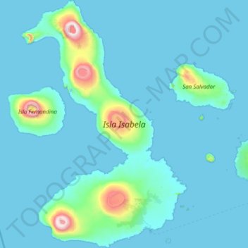
Name: Isla Isabela topographic map, elevation, terrain.
Location: Isla Isabela, Galápagos, Ecuador (-1.05406 -91.59387 0.16328 -90.78088)
Average elevation: 96 m
Minimum elevation: -1 m
Maximum elevation: 1,687 m
Make a donation
Other topographic maps
Click on a map to view its topography, its elevation and its terrain.
Wolf
Ecuador > Galápagos > Cantón Isabela
Wolf Island (Spanish: Isla Wolf) is a small island in the northern Galápagos Islands. It has an area of 1.3 km2 (0.5 sq mi) and a maximum altitude of 253 m (830 ft) above sea level. The island is remote from the main archipelago and has no permanent population. The Galápagos National Park does not allow…
Average elevation: 15 m
Isla Pinzón
Ecuador > Galápagos > Cantón Santa Cruz
Pinzón or Pinzon Island (Spanish: Isla Pinzón) is an island in Ecuador's Galápagos Archipelago. It has no permanent population, an area of 18 square kilometers (6.9 sq mi), and a maximum elevation of 458 meters (1,503 ft). Home to giant Galápagos tortoises of the subspecies Chelonoidis duncanensis and…
Average elevation: 124 m
Make a donation
Make a donation
Punta Chacabuco
Ecuador > Galápagos > Cantón San Cristóbal > Parroquia Puerto Baquerizo Moreno
Average elevation: 12 m
Roca Redonda
Ecuador > Galápagos > Cantón Isabela
Redonda Rock (Spanish: Roca Redonda, "Round Rock") is a flat-topped, steep-sided islet located roughly 25 km (16 mi) northwest of the island of Isabela in Ecuador's Galápagos Islands. Redonda measures 100 m (330 ft) long and 50 m (160 ft) wide with a maximum elevation of 67 m (220 ft). Its isolation and…
Average elevation: 0 m
Make a donation
Make a donation
Isla Plaza Sur
Ecuador > Galápagos > Cantón Santa Cruz
South Plaza (Spanish: Isla Plaza Sur) is a small island off the east coast of Santa Cruz in the Galápagos Islands. It has an area of 0.13 km2 and a maximum altitude of 23 metres.
Average elevation: 5 m
Make a donation
Make a donation