
Make a donation
East Java topographic map
Click on the map to display elevation.
Make a donation
East Java
East Java has a tropical monsoon and savanna climate at lower elevation and subtropical at higher elevation. Compared with the western part of Java Island, East Java in general has less rainfall. Average rainfall is 1,900 mm per year, with a rainy season during the 100 days. The average temperature ranges between 19–34 °C. Temperatures in the lower mountain areas, and even in areas Ranu Pani (slopes of Mount Semeru), temperatures can reach –4 °C, causing a frost and fall of light snow.
Make a donation
About this map
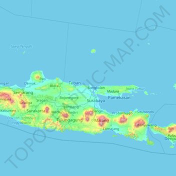
Name: East Java topographic map, elevation, terrain.
Location: East Java, Java, Indonesia (-9.03014 110.88160 -4.89269 116.48418)
Average elevation: 62 m
Minimum elevation: -1 m
Maximum elevation: 3,481 m
Make a donation
Other topographic maps
Click on a map to view its topography, its elevation and its terrain.
Make a donation
Bandung
Bandung (Sundanese: ᮘᮔ᮪ᮓᮥᮀ, romanized: Bandung, Sundanese pronunciation: [ˈbandʊŋ]; /ˈbɑːndʊŋ/) is the capital city of the Indonesian province of West Java. It has a population of 2,452,943 within its city limits according to the official estimates as at mid 2021, making it the fourth most…
Average elevation: 893 m
Make a donation
Make a donation
Tembagapura
Indonesia > Central Papua > Mimika
Tembagapura is situated on a rocky plain at an altitude of 1,930 metres (6,330 ft) at the base of Mount Zaagkam, which lies 16 kilometres (9.9 mi) southeast of the mine. The town is in the Sudirman Range, not far from Puncak Jaya (Mount Carstens), the highest peak in Oceania. The area gets about 3,220…
Average elevation: 2,488 m
Make a donation
Make a donation
Rinjani
Indonesia > West Nusa Tenggara
In September 1995 an aviation report was issued concerning an unconfirmed ash cloud from Rinjani. A NOTAM about volcanic activity from Rinjani was issued by the Bali Flight Information Region on the morning of 12 September. An ash cloud was reportedly drifting to the south west with the cloud top around 4 km…
Average elevation: 3,071 m
Make a donation
Make a donation
Make a donation
Make a donation
Make a donation
Cilacap
Indonesia > Central Java > Cilacap > Kelurahan Sidanegara Kecamatan Cilacap
Average elevation: 18 m
Make a donation
Make a donation
Make a donation
Bekasi
The City of Bekasi is a part of the Bekasi river basin, located in the downstream area of the basin with slopes ranging from 0 to 2% and elevations between 11 meters to 81 meters above sea level. The city of Bekasi is part of the Bekasi river basin and is located in the downstream area of the basin, with a…
Average elevation: 23 m
Make a donation
Make a donation
Make a donation
Make a donation
Make a donation
Make a donation
RW 15 KEL. CIHANJUANG RAHAYU KEC. PAROMPONG KAB. BANDUNG BARAT
Indonesia > West Bandung > Cisarua > Villa Istana Bunga
Average elevation: 1,377 m
Make a donation
Make a donation
Make a donation
Make a donation
Make a donation
Make a donation