
Chez Monroux topographic map
Interactive map
Click on the map to display elevation.
About this map
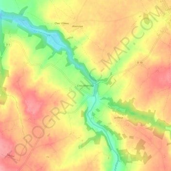
Name: Chez Monroux topographic map, elevation, terrain.
Average elevation: 165 m
Minimum elevation: 104 m
Maximum elevation: 204 m
Other topographic maps
Click on a map to view its topography, its elevation and its terrain.
Lathus
France > Nouvelle-Aquitaine > Vienne > Lathus-Saint-Rémy
Lathus, Lathus-Saint-Rémy, Montmorillon, Vienne, Nouvelle-Aquitaine, France métropolitaine, 86390, France
Average elevation: 175 m
Le Peux
France > Nouvelle-Aquitaine > Vienne > Lathus-Saint-Rémy
Le Peux, Lathus-Saint-Rémy, Montmorillon, Vienne, Nouvelle-Aquitaine, France métropolitaine, 86390, France
Average elevation: 169 m