
Ocheon-eup topographic map
Interactive map
Click on the map to display elevation.
About this map
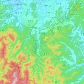
Name: Ocheon-eup topographic map, elevation, terrain.
Location: Ocheon-eup, Nam-gu, Pohang-si, North Gyeongsang, South Korea (35.85855 129.33851 35.98747 129.44032)
Average elevation: 166 m
Minimum elevation: -15 m
Maximum elevation: 642 m
Other topographic maps
Click on a map to view its topography, its elevation and its terrain.
Nam-gu
Nam-gu, Pohang-si, North Gyeongsang, South Korea
Average elevation: 97 m
Buk-gu
Buk-gu, Pohang-si, North Gyeongsang, South Korea
Average elevation: 134 m
Jukdo-dong
Jukdo-dong, Buk-gu, Pohang-si, North Gyeongsang, South Korea
Average elevation: 15 m
Jungang-dong
South Korea > Pohang-si > Jungang-dong
Jungang-dong, Buk-gu, Pohang-si, North Gyeongsang, South Korea
Average elevation: 21 m
Daesong-myeon
South Korea > Pohang-si > Daesong-myeon
Daesong-myeon, Nam-gu, Pohang-si, Gyeongsangbuk-do, South Korea
Average elevation: 151 m