
Make a donation
Whiskeytown Lake topographic map
Click on the map to display elevation.
Make a donation
About this map
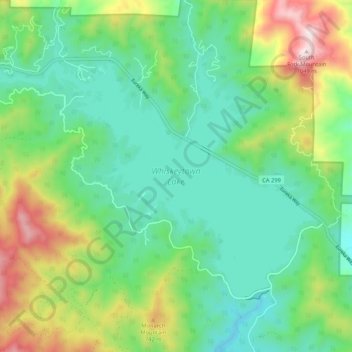
Name: Whiskeytown Lake topographic map, elevation, terrain.
Location: Whiskeytown Lake, Shasta County, California, United States (40.59801 -122.62758 40.65355 -122.52183)
Average elevation: 518 m
Minimum elevation: 291 m
Maximum elevation: 1,049 m
Make a donation
Other topographic maps
Click on a map to view its topography, its elevation and its terrain.
Yucca Valley
United States > California > San Bernardino County
Yucca Valley lies in the middle of the Morongo Basin at a base elevation of 3,300 feet. Joshua Tree National Park is adjacent to its southern border.
Average elevation: 1,106 m
Make a donation
Sugarloaf
United States > California > San Bernardino County > Big Bear City
Average elevation: 2,154 m
San Pedro Hill
United States > California > Los Angeles County > Rancho Palos Verdes
Average elevation: 285 m
Make a donation
Morgan Hill
United States > California > Santa Clara County > Morgan Hill
Morgan Hill is approximately 39 km (24 mi) south of downtown San Jose, 21 km (13 mi) north of Gilroy, and 24 km (15 mi) inland from the Pacific coast. Lying in a roughly 6 km-wide (4-mi-wide) southern extension of the Santa Clara Valley, it is bounded by the Santa Cruz Mountains to the west and the Diablo…
Average elevation: 145 m
Twentynine Palms
United States > California > Twentynine Palms
According to the United States Census Bureau, the city has a total area of 59.1 square miles (153 km2), all land. The city is at an elevation of 1,988 feet (606 m). The Marine Corps Air Ground Combat Center Twentynine Palms is located there.
Average elevation: 690 m
San Diego
United States > California > San Diego County > San Diego
The climate in San Diego, like most of Southern California, often varies significantly over short geographical distances, resulting in microclimates. In San Diego, this is mostly because of the city's topography (the Bay, and the numerous hills, mountains, and canyons). Frequently, particularly during the "May…
Average elevation: 57 m
Make a donation
Lodi
United States > California > San Joaquin County
Lodi is flat terrain at an elevation of approximately 50 feet (15 m) above mean sea level datum. Historically, land in the area has been used for grazing as well as for grain production.
Average elevation: 3 m
Altamont Pass
United States > California > Alameda County
Altamont Pass, formerly Livermore Pass, is a low mountain pass in the Diablo Range of Northern California between Livermore in the Livermore Valley and Tracy in the San Joaquin Valley. The name is actually applied to two distinct but nearby crossings of the range. The lower of the two, at an elevation of 741…
Average elevation: 339 m
Fredonyer Pass
United States > California > Lassen County
Fredonyer Pass, elevation 5,751 feet (1,753 m), is a high mountain pass in Lassen County, California, southwest of Susanville and southeast of Mount Lassen. It lies on the Great Basin Divide between the Feather River to the west and the Susan River and Honey Lake to the east.
Average elevation: 1,749 m
Make a donation
Wrightwood
United States > California > Wrightwood
Wrightwood is a census-designated place in San Bernardino County, California. It sits at an elevation of 5,935 feet (1,809 m). The population was 4,525 at the 2010 census, up from the population of 3,837 at the 2000 census. Wrightwood is located 77 miles northeast of Los Angeles.
Average elevation: 1,904 m
Make a donation
Squaw Valley
United States > California > Fresno County > Squaw Valley
Squaw Valley (formerly, Squawvalley) is a census-designated place located in Fresno County, California, in the United States. As of the 2010 census, the CDP had a total population of 3,162, up from 2,691 at the 2000 census. Despite the similar name, it is not the location of Squaw Valley Ski Resort or the 1960…
Average elevation: 557 m
Independence
United States > California > Inyo County
Independence is a census-designated place in Inyo County, California. Independence is located 41 miles (66 km) south-southeast of Bishop, at an elevation of 3930 feet (1198 m). It is the county seat of Inyo County, California. The population of this census-designated place was 669 at the 2010 census, up from…
Average elevation: 1,210 m
Make a donation
Weldon
United States > California > Kern County
Weldon is a census-designated place (CDP) in Kern County, California, United States. It sits at the southeast tip of Lake Isabella. Weldon is located 9 miles (14 km) east-southeast of Wofford Heights, at an elevation of 2,654 feet (809 m). The population was 2,642 at the 2010 census, up from 2,387 at the 2000…
Average elevation: 1,030 m
Thousand Oaks
United States > California > Ventura County > Thousand Oaks
The northern parts consist of mountainous terrain in the Simi Hills, Conejo Mountains and Mount Clef Ridge. Narrow canyons such as Hill Canyon cut through the steeper mountainous areas. Conejo Mountain and Conejo Grade are found in westernmost Newbury Park, while the southernmost parts of Thousand Oaks are…
Average elevation: 303 m
Make a donation
Placerville
United States > California > Placerville
The region east of Placerville, popularly known as Apple Hill and Pleasant Valley, is becoming a center for wine production. The wine region is officially designated as the El Dorado AVA. The largest wineries in the area are Boeger, Lava Cap and Madrona, but most of the 30 plus wineries surrounding Placerville…
Average elevation: 587 m
Make a donation
Make a donation
Independence
Independence is a census-designated place in Inyo County, California. Independence is located 41 miles (66 km) south-southeast of Bishop, at an elevation of 3930 feet (1198 m). It is the county seat of Inyo County, California. The population of this census-designated place was 669 at the 2010 census, up from…
Average elevation: 1,199 m
Make a donation
Make a donation
Make a donation
Make a donation
Make a donation
Rancho Santa Fe
The climate of Rancho Santa Fe is, for the most part, typical of the San Diego metropolitan area though its higher elevation and inland location lends itself to larger temperature variations.
Average elevation: 62 m
Make a donation
Lake Gregory
United States > California > San Bernardino County > Crestline
Average elevation: 1,452 m
Make a donation
Fort Bragg
United States > California > Mendocino County
Fort Bragg, officially the City of Fort Bragg, is a city along the Pacific Coast of California along Shoreline Highway in Mendocino County. The city is 24 miles (39 km) west of Willits, at an elevation of 85 feet (26 m). Its population was 6,983 at the 2020 census.
Average elevation: 8 m
Make a donation
Yosemite Valley
United States > California > Mariposa County > Yosemite Village > Yosemite Lodge
Average elevation: 1,479 m
Laton
United States > California > Fresno County
Laton /ˈleɪtən/ is a census-designated place (CDP) in Fresno County, California, United States. The population was 1,824 at the 2010 census, up from 1,236 at the 2000 census. Laton is located 23 miles (37 km) south-southeast of Fresno, at an elevation of 259 feet (79 m).
Average elevation: 79 m
Mariposa
United States > California > Mariposa County
Mariposa is located at 37°29′06″N 119°57′59″W / 37.48500°N 119.96639°W / 37.48500; -119.96639, at 1,949 feet (594 m) in elevation. It lies in the rugged foothills of the Sierra Nevada. Mariposa Creek flows through the town. Soils in the urban area are mostly brown to reddish brown loam of…
Average elevation: 688 m
Make a donation
Menifee
United States > California > Riverside County
Menifee is a city in Riverside County, California, United States, and part of the Los Angeles Combined Statistical Area. The city is centrally located in Southern California in the Menifee Valley. It is almost 15 miles (24 km) north of Temecula and just north of Murrieta. Menifee is roughly 46 square miles…
Average elevation: 456 m
Bolsa Chica Wetlands
United States > California > Orange County > Huntington Beach
Average elevation: 7 m
Pollock Pines
United States > California > El Dorado County
Pollock Pines is a census-designated place (CDP) in El Dorado County, California, United States. It is part of the Sacramento–Arden-Arcade–Roseville Metropolitan Statistical Area. Pollock Pines lies at an elevation of 3,980 feet (1,210 m) in the Sierra Nevada. The population was 6,871 at the 2010 census,…
Average elevation: 1,122 m
Make a donation
Newbury Park
United States > California > Ventura County > Thousand Oaks
Newbury Park can be described as a town,[6] community,[94] or section[9] mostly within the Thousand Oaks city limits in addition to rural areas west of Thousand Oaks. Newbury Park is bordered by Lynn Road in the east and the Conejo Grade on the west. It borders the Santa Monica Mountains in the south, while…
Average elevation: 262 m
Altamont Pass
United States > California > Alameda County > Altamont
Altamont Pass, formerly Livermore Pass, is a low mountain pass in the Diablo Range of Northern California between Livermore in the Livermore Valley and Tracy in the San Joaquin Valley. The name is actually applied to two distinct but nearby crossings of the range. The lower of the two, at an elevation of 741…
Average elevation: 277 m
Make a donation
Desert Knolls Manor
United States > California > San Bernardino County > Apple Valley
Average elevation: 928 m
Crescent City
United States > California > Del Norte County
The topography of the sea floor surrounding Crescent City has the effect of focusing tsunamis. According to researchers at Humboldt State University and the University of Southern California, the city experienced tsunami conditions 31 times between the years 1933 and 2008. Although many of these incidents were…
Average elevation: 31 m
Make a donation
Susanville
United States > California > Lassen County
Susanville (formerly known as Rooptown) is a town in and is the county seat of Lassen County, California, United States. Susanville is located on the Susan River in the southern part of the county, at an elevation of 4,186 feet (1,276 m). Its population is 16,728 as of the 2020 census, down from 17,947 from…
Average elevation: 1,345 m
Mammoth Lakes
United States > California > Mammoth Lakes
Mammoth Lakes is a town in Mono County, California, the county's only incorporated community. It is located immediately to the east of Mammoth Mountain, at an elevation of 7,880 feet (2,400 m). As of the 2010 United States Census, the population was 8,234, reflecting a 16% increase from the 2000 Census.
Average elevation: 2,184 m
Lancaster
United States > California > Lancaster
According to the United States Census Bureau, the city has a total area of 94.5 square miles (245 km2), of which 94.3 square miles (244 km2) is land and 0.3 square miles (0.78 km2) (0.29%) is water. Lancaster's elevation is 2,350 feet (720 m) above sea level on a high, flat valley surrounded by pristine…
Average elevation: 787 m
Make a donation
Pinedale
United States > California > Fresno County > Fresno
Pinedale is a previously unincorporated community in Fresno County, California. It lies at an elevation of 348 feet (106 m). It was once a rural community located on the Southern Pacific Railroad 3.5 miles (5.6 km) north-northwest of Clovis but has since become surrounded and annexed by the city of Fresno.…
Average elevation: 107 m
Idyllwild-Pine Cove
United States > California > Riverside County
"Mile-high Idyllwild" is a mountain resort about one-mile (1,600 m) in altitude. Idyllwild is flanked by two large rock formations, Tahquitz Peak and Suicide Rock (also known as Lily Rock), which are famous in Southern California rock-climbing circles. It offers no skiing, so "the Hill" has been minimally…
Average elevation: 1,746 m
Make a donation
Make a donation
Lakeport
United States > California > Lake County
Lakeport is an incorporated city and the county seat of Lake County, California. This city is 125 miles (201 km) northwest of Sacramento. Lakeport is on the western shore of the county namesake, Clear Lake, at an elevation of 1,355 feet (413 m). The population was 5,026 at the 2020 census, up from 4,753 at the…
Average elevation: 417 m
Make a donation