
Dover topographic map
Interactive map
Click on the map to display elevation.
About this map
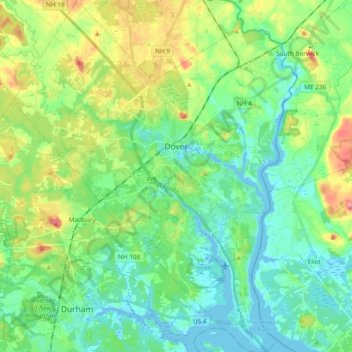
Name: Dover topographic map, elevation, terrain.
Location: Dover, Strafford County, New Hampshire, 03820, United States (43.11764 -70.96161 43.25498 -70.81902)
Average elevation: 31 m
Minimum elevation: -9 m
Maximum elevation: 106 m
According to the United States Census Bureau, the city has a total area of 29.0 square miles (75.2 km2), of which 26.7 square miles (69.2 km2) are land and 2.3 square miles (6.0 km2) are water, comprising 7.97% of the city. Dover is drained by the Cochecho and Bellamy rivers, both of which flow into the tidal Piscataqua River, which forms the city's eastern boundary and the New Hampshire–Maine border. Long Hill, elevation greater than 300 feet (91 m) above sea level and located 3 miles (5 km) northwest of the city center, is the highest point in Dover. Garrison Hill, elevation approximately 290 ft (88 m), is a prominent hill rising directly above the center city, with a park and lookout tower on top.
Other topographic maps
Click on a map to view its topography, its elevation and its terrain.
Rochester
United States > New Hampshire > Strafford County
Rochester, Strafford County, New Hampshire, United States
Average elevation: 90 m
New Durham
United States > New Hampshire > Strafford County
New Durham, Strafford County, New Hampshire, 03855, United States
Average elevation: 228 m
Barrington
United States > New Hampshire > Strafford County
Barrington, Strafford County, New Hampshire, United States
Average elevation: 93 m
Somersworth
United States > New Hampshire > Strafford County
Somersworth, Strafford County, New Hampshire, 03878, United States
Average elevation: 56 m
Hornetown
United States > New Hampshire > Strafford County > Farmington
Hornetown, Farmington, Strafford County, New Hampshire, United States
Average elevation: 225 m
Dover
United States > New Hampshire > Strafford County > Dover
Dover, Strafford County, New Hampshire, 03820, United States
Average elevation: 52 m
Middleton
United States > New Hampshire > Strafford County
Middleton, Strafford County, New Hampshire, 03887, United States
Average elevation: 233 m
Milton
United States > New Hampshire > Strafford County
Milton, Strafford County, New Hampshire, United States
Average elevation: 183 m
Madbury
United States > New Hampshire > Strafford County
Madbury, Strafford County, New Hampshire, 03823, United States
Average elevation: 34 m
Farmington
United States > New Hampshire > Strafford County
Farmington, Strafford County, New Hampshire, 03835, United States
Average elevation: 168 m
Rochester
United States > New Hampshire > Strafford County > Rochester
Rochester, Strafford County, New Hampshire, 03867, United States
Average elevation: 118 m
Piper Mountain
United States > New Hampshire > Strafford County > Middleton
Piper Mountain, Middleton, Strafford County, New Hampshire, 03887, United States
Average elevation: 216 m
Strafford
United States > New Hampshire > Strafford County
Strafford, Strafford County, New Hampshire, United States
Average elevation: 202 m
Durham
United States > New Hampshire > Strafford County
Durham, Strafford County, New Hampshire, 03824, United States
Average elevation: 23 m