
Uzundere topographic map
Interactive map
Click on the map to display elevation.
About this map
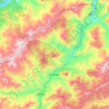
Name: Uzundere topographic map, elevation, terrain.
Location: Uzundere, Erzurum, Doğu Anadolu Bölgesi, Turquie (40.47016 41.40981 40.69218 41.75883)
Average elevation: 1,815 m
Minimum elevation: 732 m
Maximum elevation: 3,069 m
Other topographic maps
Click on a map to view its topography, its elevation and its terrain.
Uzundere Mahallesi
Uzundere Mahallesi, Uzundere, Erzurum, Région de l'Anatolie orientale, Turquie
Average elevation: 1,377 m