
Oberes Dorf topographic map
Interactive map
Click on the map to display elevation.
About this map
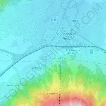
Name: Oberes Dorf topographic map, elevation, terrain.
Average elevation: 711 m
Minimum elevation: 649 m
Maximum elevation: 1,004 m
Other topographic maps
Click on a map to view its topography, its elevation and its terrain.
Almdorf
Österreich > Tirol > Bezirk Kitzbühel > Marktgemeinde St. Johann in Tirol
Almdorf, Marktgemeinde St. Johann in Tirol, Bezirk Kitzbühel, Tirol, 6380, Österreich
Average elevation: 728 m
Scheffau
Österreich > Tirol > Bezirk Kitzbühel > Marktgemeinde St. Johann in Tirol
Scheffau, Marktgemeinde St. Johann in Tirol, Bezirk Kitzbühel, Tirol, Österreich
Average elevation: 939 m