
Thank you for supporting this site ❤️
Make a donation
Make a donation
Mahimangad topographic map
Click on the map to display elevation.
Thank you for supporting this site ❤️
Make a donation
Make a donation
About this map
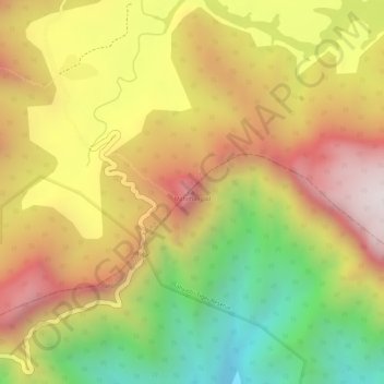
Name: Mahimangad topographic map, elevation, terrain.
Location: Mahimangad, Khed, Ratnagiri District, Maharashtra, India (17.71102 73.61030 17.71112 73.61040)
Average elevation: 643 m
Minimum elevation: 235 m
Maximum elevation: 968 m
Thank you for supporting this site ❤️
Make a donation
Make a donation
Other topographic maps
Click on a map to view its topography, its elevation and its terrain.