
Make a donation
Ventura County topographic map
Click on the map to display elevation.
Make a donation
Ventura County
Ventura County can be separated into two major parts, East County and West County, which are divided by the Conejo Grade.[50] East County consists of all cities east of the Conejo Grade. Geographically East County is the end of the Santa Monica Mountains, in which the Conejo Valley is located, and where there is a considerable increase in elevation. Communities which are considered to be in the East County are Thousand Oaks, Newbury Park, Lake Sherwood, Hidden Valley, Santa Rosa Valley, part of Westlake Village, Oak Park, Moorpark, and Simi Valley.[citation needed] A majority of these communities are in the Conejo Valley.
Make a donation
About this map
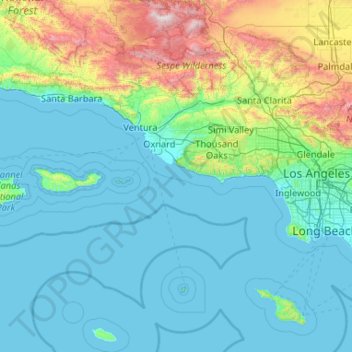
Name: Ventura County topographic map, elevation, terrain.
Location: Ventura County, California, United States (33.16349 -119.75770 34.90127 -118.63249)
Average elevation: 331 m
Minimum elevation: -1 m
Maximum elevation: 2,671 m
Make a donation
Other topographic maps
Click on a map to view its topography, its elevation and its terrain.
Hope Ranch
United States > California > Santa Barbara County
Hope Ranch occupies a hilly area immediately adjacent to the coast; the highest elevation is 691 feet (211 m). The northern boundary of the hilly area is Cieneguitas Creek, which flows down the topographic expression of the More Ranch Fault; this ravine also helps define the informal northern boundary of the…
Average elevation: 43 m
Make a donation
Make a donation
Make a donation
Yosemite Valley
United States > California > Mariposa County > Yosemite Village
Average elevation: 2,016 m
Make a donation
Make a donation
Serrano Village
United States > California > San Bernardino County > San Bernardino
Average elevation: 489 m
Make a donation
Pollock Pines
United States > California > El Dorado County > Pollock Pines
Pollock Pines is a census-designated place (CDP) in El Dorado County, California, United States. It is part of the Sacramento–Arden-Arcade–Roseville Metropolitan Statistical Area. Pollock Pines lies at an elevation of 3,980 feet (1,210 m) in the Sierra Nevada. The population was 7,112 at the 2020 census,…
Average elevation: 1,118 m
Make a donation
El Dorado Hills
United States > California > El Dorado County > Folsom
El Dorado Hills (EDH), as defined by the 2010 census-designated place (CDP), is at the western border of El Dorado County, between the City of Folsom and the unincorporated community of Cameron Park. The northern limits of the CDP are Folsom Lake and the South Fork of the American River, where river rafters…
Average elevation: 243 m
San Francisco
United States > California > City and County of San Francisco > San Francisco
Average elevation: 40 m
Make a donation
Make a donation
Make a donation
Pine Mountain Club
United States > California > Kern County
Pine Mountain Club has an area of 16.7 square miles (43.25 km2). It ranges from 4,901 to 6,400 feet (1,494 to 1,951 m) in elevation. The community sits in a deep valley of the San Emigdio Mountains, on the San Andreas fault. It is surrounded by Los Padres National Forest. The settlement lies between Apache…
Average elevation: 1,867 m