
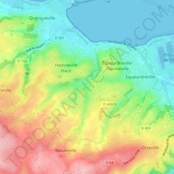
Équeurdreville-Hainneville topographic map
Interactive map
Click on the map to display elevation.
About this map
Name: Équeurdreville-Hainneville topographic map, elevation, terrain.
Average elevation: 60 m
Minimum elevation: -3 m
Maximum elevation: 152 m
La ville est traversée en son centre par le ruisseau de la Bonde qui forme une petite vallée. D'autres ruisseaux (ruisseau du Fay, le Vaublat…) creusent également des sillons, créant des vaux et des encaissements. Équeurdreville-Hainneville est donc assez escarpée par endroits et l'altitude monte rapidement.
Other topographic maps
Click on a map to view its topography, its elevation and its terrain.
Hameau Burnel
France > Normandie > Manche > Cherbourg-en-Cotentin
Hameau Burnel, Tourlaville, Cherbourg-en-Cotentin, Cherbourg, Manche, Normandie, France métropolitaine, 50110, France
Average elevation: 61 m
La Glacerie
France > Normandie > Manche > Cherbourg-en-Cotentin
La Glacerie, Cherbourg-en-Cotentin, Cherbourg, Manche, Normandie, France métropolitaine, 50470, France
Average elevation: 114 m
Tourlaville
France > Normandie > Manche > Cherbourg-en-Cotentin
Tourlaville, Cherbourg-en-Cotentin, Cherbourg, Manche, Normandie, France métropolitaine, 50110, France
Average elevation: 34 m
Cherbourg-Octeville
France > Normandie > Manche > Cherbourg-en-Cotentin
Cherbourg-Octeville, Cherbourg-en-Cotentin, Cherbourg, Manche, Normandie, France métropolitaine, France
Average elevation: 39 m
Hameau des Champs
France > Normandie > Manche > Cherbourg-en-Cotentin
Hameau des Champs, Tourlaville, Cherbourg-en-Cotentin, Cherbourg, Manche, Normandie, France métropolitaine, 50110, France
Average elevation: 76 m
Querqueville
France > Normandie > Manche > Cherbourg-en-Cotentin
Querqueville, Cherbourg-en-Cotentin, Cherbourg, Manche, Normandie, France métropolitaine, 50460, France
Average elevation: 50 m
Le Becquet de Tourlaville
France > Normandie > Manche > Cherbourg-en-Cotentin
Le Becquet de Tourlaville, Tourlaville, Cherbourg-en-Cotentin, Cherbourg, Manche, Normandie, France métropolitaine, 50110, France
Average elevation: 32 m
Les Noires Mares
France > Normandie > Manche > Cherbourg-en-Cotentin
Les Noires Mares, Équeurdreville-Hainneville, Cherbourg-en-Cotentin, Cherbourg, Manche, Normandie, France métropolitaine, 50120, France
Average elevation: 56 m
Ouvrage Saint-Gabriel
France > Normandie > Manche > Cherbourg-en-Cotentin > Les Charmettes
Ouvrage Saint-Gabriel, D 63, Les Charmettes, Tourlaville, Cherbourg-en-Cotentin, Cherbourg, Manche, Normandie, France métropolitaine, 50110, France
Average elevation: 90 m
Hameau Saint-Jean
France > Normandie > Manche > Cherbourg-en-Cotentin > Hameau Saint-Jean
Hameau Saint-Jean, Tourlaville, Cherbourg-en-Cotentin, Cherbourg, Manche, Normandie, France métropolitaine, 50110, France
Average elevation: 92 m